


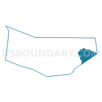
Voting District 050003, Montgomery County, New York
About
Outline

Summary
| Unique Area Identifier | 630494 |
| Name | Voting District 050003 |
| County | Montgomery County |
| State | New York |
| Area (square miles) | 21.61 |
| Land Area (square miles) | 21.21 |
| Water Area (square miles) | 0.40 |
| % of Land Area | 98.16 |
| % of Water Area | 1.84 |
| Latitude of the Internal Point | 42.88537300 |
| Longtitude of the Internal Point | -74.16171030 |
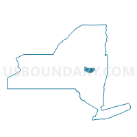
Maps

Graphs
Select a template below for downloading or customizing gragh for Voting District 050003, Montgomery County, New York


Neighbors
Neighoring Voting District (by Name) Neighboring Voting District on the Map
- Voting District 010001, Schenectady County, NY
- Voting District 010002, Schenectady County, NY
- Voting District 010003, Montgomery County, NY
- Voting District 020003, Schenectady County, NY
- Voting District 020504, Montgomery County, NY
- Voting District 040001, Schenectady County, NY
- Voting District 050001, Montgomery County, NY
- Voting District 050001, Schenectady County, NY
Top 10 Neighboring County Subdivision (by Population) Neighboring County Subdivision on the Map
- Glenville town, Schenectady County, NY (29,480)
- Rotterdam town, Schenectady County, NY (29,094)
- Amsterdam city, Montgomery County, NY (18,620)
- Duanesburg town, Schenectady County, NY (6,122)
- Amsterdam town, Montgomery County, NY (5,566)
- Florida town, Montgomery County, NY (2,696)
- Princetown town, Schenectady County, NY (2,115)
Top 10 Neighboring Place (by Population) Neighboring Place on the Map
Top 10 Neighboring Unified School District (by Population) Neighboring Unified School District on the Map
- Amsterdam City School District, NY (25,711)
- Scotia-Glenville Central School District, NY (18,677)
- Schalmont Central School District, NY (13,872)
Top 10 Neighboring State Legislative District Lower Chamber (by Population) Neighboring State Legislative District Lower Chamber on the Map
Top 10 Neighboring State Legislative District Upper Chamber (by Population) Neighboring State Legislative District Upper Chamber on the Map
Top 10 Neighboring 111th Congressional District (by Population) Neighboring 111th Congressional District on the Map
Top 10 Neighboring Census Tract (by Population) Neighboring Census Tract on the Map
- Census Tract 331.02, Schenectady County, NY (6,122)
- Census Tract 721, Montgomery County, NY (5,566)
- Census Tract 728, Montgomery County, NY (4,069)
- Census Tract 326.02, Schenectady County, NY (4,005)
- Census Tract 702, Montgomery County, NY (2,380)
- Census Tract 325.04, Schenectady County, NY (2,251)
- Census Tract 331.01, Schenectady County, NY (2,115)
- Census Tract 709, Montgomery County, NY (1,616)